Wednesday, March 31, 2010

Development: Ivy Tech, St. Vincent Recap and Siteplan

The old St. Vincent Hospital between Capitol Ave. and Illinois St. at Fall Creek Parkway potentially faced the wrecking ball in July 2008. Ivy Tech was in need of new classroom space and had deemed St. Vincent Hospital -- until 2002 a public housing project and sold to Ivy Tech for $1 in 2006 -- unsuitable for classroom conversion. They proposed razing St. Vincent and building this classroom building:


Fortunately, the Indiana Historic Landmarks Foundation quickly stepped in and put an end to that talk. St. Vincent was temporarily saved, while Ivy Tech was left in a bind, with a need for new classroom space to support a student body that continued to grow unabated.

In early 2009, a plan was floated to convert St. Vincent into student housing. The project would have provided an $18M renovation of St. Vincent and space for 250 students to live, while Ivy Tech would have turned to other land on their campus for construction of a new classroom building. Perhaps due to poor financial timing by the developers involved, that plan fizzled rather quickly, forcing Ivy Tech back to the drawing board.

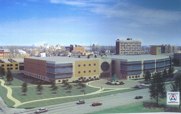
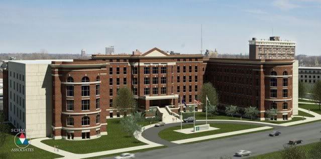
By mid 2009, Ivy Tech had produced another new plan, a compromise with historical preservationists that would save the southern, Fall Creek Parkway facade of St. Vincent Hospital and construct a new building behind it (a process commonly called facadectomy). Here is a rendering of the proposal:


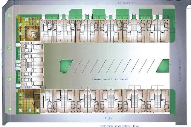
Facadectomy is a controversial process and the proposal lead to quite a debate around the internet. Despite the controversy, Ivy Tech is proceeding with its facadectomy plan and demolition of the building is currently underway. Thanks to Chris Barnett of the Near North Development Corporation, here is the siteplan for the future Ivy Tech building, which will feature classrooms and laboratories, as well as student services and community space:


For comparison, here is an overhead shot of the site as of 2005:


Curt at Huston Street Racing has a photo in a recent post that shows some of the demolition work currently being done on St. Vincent. Also see an earlier post here at DIG-B, showing the state of the building in August 2008 when total demolition seemed imminent.

Tuesday, March 30, 2010

300 Posts and a New Blog Description

Looking over my blog layout yesterday, I decided it was a good time to tweak to my blog description. I ended up rewriting the whole thing:
When it comes to development projects, traditional media outlets generally tell you about three things:

Project Announcement
Groundbreaking
Grand Opening

What about all the dirty work in-between? That’s where DIG-B comes in. I attempt to follow as many projects as possible -- focusing primarily on the downtown Indianapolis area -- providing photographic updates of the construction progress.

This isn’t art -- I don’t claim to be an expert photographer and I don’t edit my photos. This is simply timestamping Indianapolis placemaking.
I've never explicitly stated that last paragraph, but that's always been my goal. Sometimes I get lucky with cool photos, but mostly I just point my camera at things, upload the photos and post them. Nothing fancy here.

Once I was done rewriting the description, I decided that it might be good to publish it along with post #300, which I knew was coming up soon. A quick tabulation showed that my timing was impeccable: yesterday's Cosmopolitan post was #299.

As always, thanks to everybody that reads and comments!

Monday, March 29, 2010

Photos: Cosmopolitan on the Canal -- The Left Bank Patio

The Left Bank coffee shop -- operated by street-level neighbor Mo'Joe Coffeehouse -- will be occupying the canal-front retail space of the Cosmopolitan on the Canal. A concrete patio for canal-side outdoor seating began to be poured on Friday and The Left Bank is expected to open in early May. Here's a peak at the first stage (they have since poured more).


A cozy corner immediately north of the Indiana Historic Landmarks Foundation Headquarters.


Looking north, a view of the entire canal frontage.


The entrance for The Left Bank.


According to the leasing office, this side of the retail frontage (the northern half) is a residents social area. The Left Bank will be in the southern portion of the space, and looking through the windows, it appears that there is no strict partition (a two-sided fireplace roughly divides the space). EDIT (4/4/10): The sidewalks are done and you can now walk right up and look in the windows. There is definitely a full wall separating the Left Bank Cafe from the rest of the space. The Left Bank will only occupy about one-third of the canal-front space to boot. Very unfortunate.

Monday, March 15, 2010

Photo: Indianapolis Cultural Trail, Photo 24

The North Corridor of the Cultural Trail will feature new traffic lights at the intersections of Walnut St. with Senate Ave., Capitol Ave, and Illinois St. These intersections were previously all free flowing for the streets crossing Walnut St. New street light masts have been installed at all these intersections, though the lights have not yet been installed. Here is one of the masts at Walnut St. and Senate Ave.:

Looking northeast at the intersection of Walnut St. and Senate Ave.

Friday, March 12, 2010

Development: Sarojo Commons Siteplan

Thanks to an anonymous reader for providing this siteplan for Sarojo Commons. The details will be tough to make out, but you can get a rough idea of the layout of the project.

The siteplan for Sarojo Commons, with Capitol Ave at left, St. Clair St. at
top, Muskingum St. (an alley) at right and an unnamed alley at bottom.

I was unaware that the project was so "thin", with the interior parking/driving area occupying over a third of the site. On the bright side, that interior area will feature permeable pavement. Keep Indianapolis Beautiful and The Nature Conservancy have permeable pavement in their parking lots, but Sarojo Commons will be the first non-environmentally-oriented development to feature this material in downtown.

Thursday, March 11, 2010

Photos: Indianapolis Cultural Trail, Photo 23

As part of the design of the North Corridor of the Cultural Trail, the intersection of St. Clair St. and Dr. Martin Luther King Jr. St. was shifted slightly north to accommodate the Trail on the south side of St. Clair St. This is what the intersection looks like today:

Looking east from the southwest corner of the intersection.

The center island of Dr. Martin Luther King Jr. St. was extended significantly to the north
to provide a safe stopping zone for those unable to cross the street in the available time.

Wednesday, March 10, 2010

Photos: Construction Begins on Sarojo Commons

Site clearing began for Sarojo Commons about a month ago and concrete foundations are now beginning to be poured. Here's a peak at the work being done on the southeast corner of Capitol Ave. and St. Clair St.

Looking south, Capitol Ave. at right.

Looking east, St. Clair St. at left.

The entire site, looking southeast across the intersection of Capitol Ave. and St. Clair St.

A rendering of Sarojo Commons, submitted to the Metropolitan Development Commission.

Tuesday, March 9, 2010

Photos: Indianapolis Cultural Trail, Photo 22 (Set)

Indianapolis Power & Light has been working nearly every day for the last couple of weeks at the intersection of Dr. Martin Luther King Jr. St. and St. Clair St. They appear to be restringing power lines to different poles so that poles blocking the Cultural Trail and St. Clair St. can finally be removed. These photos depict the current state, with poles periodically sticking out of the road and the trail.


Looking east on St. Clair near the intersection with Fayette St.


Looking east on the Cultural Trail near the Central Canal.


Looking west on the Cultural Trail near the intersection of St. Clair St. and California St.

Monday, March 8, 2010

Photos: AJ's Lounge at Senate Manor

What a difference some paint and new awnings can make. The new owners of Senate Manor (Senate Ave. and North St.) have been busy for the past several months renovating the 77-unit, two-building complex into "upscale apartments." They also gave the facade of AJ's Lounge, a small neighborhood bar, a nice upgrade.

February 8, 2009

March 7, 2010

Thursday, March 4, 2010

Methodist Hospital Bed Tower Vision

Clarian Health and the Methodist Health Foundation recently launched a philanthropic partnership called "Lighting the Way: the Campaign for Methodist Hospital." The campaign is designed to support critical care at Methodist Hospital with the goal of raising $100M. A large portion of this money will be used to construct a new bed tower at Methodist Hospital. An artistic vision of this tower was recently released in a Clarian newsletter:


The caption with this picture reads, "Although the exact specifications for the proposed bed
tower are yet to be determined, an architect's depiction illustrates the vision's potential."

Noting the distinctive Methodist Lighthouse and the facade of the Julius A. Hanson Unit at left, this tower proposal hints that they intend to replace an existing 8-story building located on the southwest corner of Capitol Ave. and 18th St. The new tower appears to be roughly 14 stories tall.

With copious unused land around their existing campus of buildings, it seems a strange choice to demolish a building for construction of this tower. Other factors may be at play -- the existing building may be in need of significant repairs and/or features an obsolete design. In any case, this project is likely years from coming to fruition.