Wednesday, June 9, 2010

Development: Buckingham Moving on YMCA Redevelopment

The bulldozers are hard at work at 860 W. 10th St., clearing away an aging YMCA to make way for a new mixed-use development by locally-based Buckingham Co. When they were selected by the Center Township Advisory Board to redevelopment this site in December 2009, this is how Buckingham envisioned the development:


On a pass on the Clarian People Mover yesterday, I observed that the majority of the low-rise section of the YMCA had been razed, while the larger 4-story structure was still standing. The Indy Star reports that Buckingham expects the demolition to last through the end of June.

Buckingham also recently filed for a variance to their pre-approved siteplan that will be heard by the Metropolitan Development Commission Hearing Examiner tomorrow at 1pm. The variance relates to underground utilities that have been deemed cost-prohibitive to relocate. The proposed siteplan is below, and it appears to show utility lines entering the site at the NE corner of the intersection of 10th St. and Indiana Ave. (apologies about the bluriness -- this is the quality provided in the online staff report).

10th St. at bottom, Brooks St. at right, and Indiana Ave. angling off the left edge of the siteplan.
Note that the plan appears to show 13 curb-side parking spaces on 10th St.

According to the variance filing, the 5-story commercial/residential structure lining 10th St. has been shortened by 60' and the 4-story residential structure at the western edge of the site has been elongated by the same 60'. This would theoretically retain the residential capacity of the project. However, as the ground floor of the 10th St. structure is to house the commercial space, it's not immediately clear what effect this adjustment will have on that aspect of the project.

Wednesday, June 2, 2010

Photos: The Di Rimini Construction Update

Sarojo Commons -- the working name for a low-rise student apartment building currently under construction on the southeast corner of Capitol and St. Clair -- has been renamed The Di Rimini. According to the website, every unit will be 2BR with both furnished and unfurnished options. Here are some photos of the on-going construction process:


Looking east at the Capitol Ave. frontage.


Looking east along the St. Clair St. frontage.


Detail of the ground floor stone facade.

Tuesday, June 1, 2010

Development: New Project Coming to Downtown Canal Walk?

The Kirkbride Bible Company has operated out of a warehouse at the intersection of 9th St. and the Central Canal since 1984*. Over the last 26 years, and particularly in the last 10 or so, a lot has changed in the area immediately around that warehouse. The canal, an unkempt industrial waterway when Kirkbride first moved in, is now a lively linear urban park. Likewise, industrial structures lining the canal have given way to residential, medical research, and institutional uses, among others. The Kirkbride warehouse sticks out as an odd use on the Central Canal today, one of the last vestiges of its industrial past and one of the last great redevelopment opportunities along the Downtown Canal Walk.

According to a filing with the Indianapolis Department of Metropolitan Development (DMD), Kirkbride has moved on from their canal-front warehouse -- "The existing building on the site was used as a manufacturing facility and is currently vacant" -- and their 1.2 acre site* might be redeveloped as a mixed-use residential/commercial project. In the May 27th Staff Report for the DMD Hearing Examiner, there is a continued petition for 335 West 9th Street (the former address of Kirkbride) to be rezoned to CBD-2, a designation in line with other redeveloped properties fronting the canal. An image of the site from the DMD staff report:

St. Clair St. angles off the left side, while Senate Ave. angles toward the top of this image.

Embedded within the rezoning petition are many interesting details:

1. The 'Comprehensive Plan' section notes, "The site is located within the boundaries of the Regional Center Plan 2020 which recommends residential development of 27 to 49 units per acre."

Assuming this project follows the Regional Center Planning recommendations, it would include 27-49 units/acre * 1.2 acres = 32 to 59 units.

2. The 'Land Use' section adds, "Staff would suggest that grade level commercial use on the west elevation of this building be integrated into the design. The building’s design should foster an active streetscape along the canal, consistent with other canal development. The petitioner has verbally indicated that grade level commercial use is intended for this development."

It should almost go without saying that any canal-front redevelopment needs to be attentive to the canal "streetscape", but I'm glad that the staff has specifically recommended commercial uses at canal level.

3. The 'Regional Center' section of the petition reads, "Staff has verbally indicated that the proposed development would be considered a ‘High Impact’ Project in accordance with the Regional Center Urban Design Guidelines."

This designation requires a public hearing before the Regional Center Hearing Examiner, so anyone who wants to have a say in the design of this project will get their time.

4. The petition also has a May 27th staff addendum that reads, "It was anticipated that this petition would be amended to included additional property. As of this writing, this petition has not been amended, nor new notice provided. Staff understands that this petition will be continued to at least June 24, 2010."

The warehouse immediately to the south of Kirkbride, formerly the home of B.H. Gardner Co., was until recently listed for sale. The site no longer has a for sale sign so it could be assumed that the petitioners are trying to fold this property into a larger rezoning petition and redevelopment project.

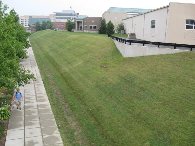
Looking North from the St. Clair St. bridge over the Canal. The B.H. Gardner warehouse is the first building on the right, fronted by the black railing. The Kirkbride warehouse with a gray/brown brick front is immediately beyond the cluster of pine trees.

In closing, and just to be perfectly clear: not only does this rezoning petition not necessarily mean any redevelopment will ultimately move forward for this site, but this particular petition was continued, meaning that it was not voted upon and will be reconsidered at the next meeting of the DMD Hearing Examiner. That said, it's certainly exciting to think about another project popping up along the banks of the canal.

* Facts taken from an IBJ article about the adjacent Kirkbride and BH Gardner sites for sale, September '09.

Wednesday, April 28, 2010

Photos: Indianapolis Cultural Trail Glick Peace Walk

Work on the Glick Peace Walk continues on the two blocks of Walnut between Capitol and Meridian. There are a total of 10 installations on these blocks, with two more to be installed downtown on the Central Corridor (directions to the other 10 will be included at these two pieces). Here's how the designers envision the walk.


And here's a peak at the on-going work for a few of the honorees.


Photos taken April 17, 2010.

Tuesday, April 27, 2010

Development: Lugar Tower Redevelopment Siteplan

Flaherty & Collins won the rights to develop city-owned land around the base of both Barton Tower on Massachusetts Ave. and Lugar Tower on Fort Wayne Ave. in mid 2009. The Barton Tower redevelopment opportunity receives the lion's share of attention due to its strategic position in the heart of Mass Ave and because the 500 block represents a dead zone, dividing an otherwise thriving urban corridor.

The Lugar Tower proposal, fronting Fort Wayne Ave., seems to be an afterthought, though I believe it to be equally important. There's an opportunity for Fort Wayne to be a wonderful neighborhood-serving commercial street if development is planned out in a thoughtful manner. I recently came across the following siteplan for the Lugar Tower redevelopment (as always, be sure to click on the image so you can see a larger version with more detail):


A couple quick thoughts and then I'll open it up for discussion in the comments:

1. The Urban Times article linked above indicates that the redevelopment opportunity was for both the Fort Wayne side and the East St. sides of Lugar Tower. It could be that those are two different plans with two different architectural designs. It could be that East St. plans are on hold for now. Who knows.

2. I'm not a fan of two curb cuts on Fort Wayne that close together.

3. However, I am a big fan of the new curb cut for a road that places Lugar Tower on a logical street grid. In one quick design move, the placement of that tower suddenly makes sense. Lining the road with new residential units should create a great entry to the tower loading loop.

What do you think?